The Newyorkworld: New York City streets are free to walk, but until now getting the city’s master map database cost dearly.
That changed on Thursday, when the Department of City Planning made MapPLUTO — an extensive database full of information about each of the city’s parcels of land — available to the public on its website, free of charge.
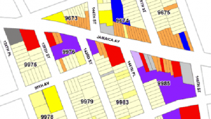
Previously, the same files came at a steep price of $300 per borough, and a required license barred users from posting any of the data, including maps, on the Internet.
“We revised our policy on the sale of PLUTO and MapPLUTO data in keeping with the Mayor’s ongoing commitment to using technology to improve customer service and transparency,” a Department of Planning spokesperson wrote in an email on Thursday.
In April, The New York World reported that even as the city moved to put vital government data online for free download, MapPLUTO remained a glaring exception.”
New York City liberates map data trove
How to contribute:
Did you come across – or create – a compelling project/report/book/app at the leading edge of innovation in governance?
Share it with us at info@thelivinglib.org so that we can add it to the Collection!
About the author
Get the latest news right in you inbox
Subscribe to curated findings and actionable knowledge from The Living Library, delivered to your inbox every Friday
Related articles
citizen engagement
Making Civic Trust Less Abstract: A Framework for Measuring Trust Within Cities
Posted in June 5, 2025 by Stefaan Verhulst
artificial intelligence
The AI Policy Playbook
Posted in June 5, 2025 by Stefaan Verhulst
DATA
Europe’s dream to wean off US tech gets reality check
Posted in June 5, 2025 by Stefaan Verhulst